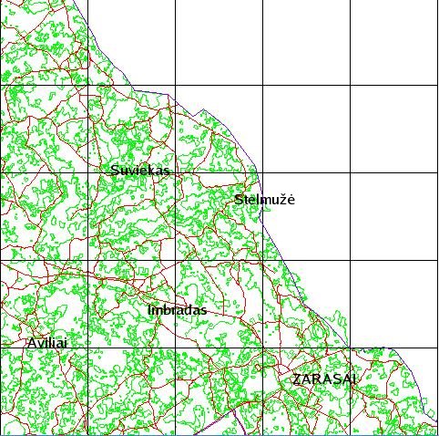
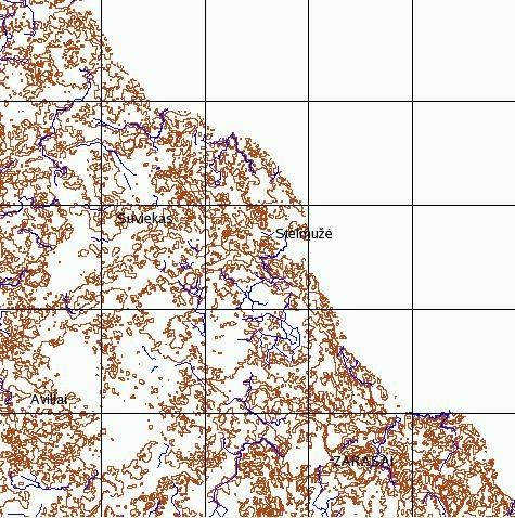
Geographic map of Lithuania
National land survey of Lithuania, 2001
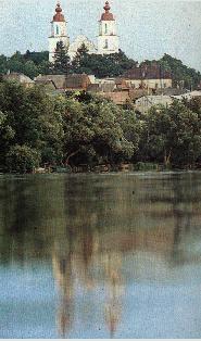
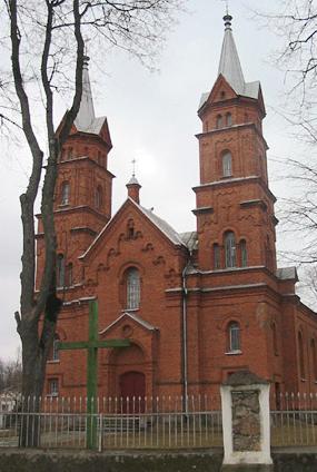
The church Švč. Mergelė Ėmimo į dangų was built in 1878
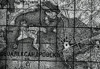
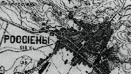
Novoaleksandrovsk, 1898
Topographic map of Russia 1:42000. 1898
|
Before the start of globalization, there existed local culturally sustaining connections between geographical place and cultural experience. These connections constituted community’s ‘cultural identity’. This identity was something people simply ‘had’ as an inheritance, a path of continuity with the past. Identity, like language, was not just a description of cultural belonging; it was a sort of collective treasure of local communities. But it was also discovered to be something fragile that needed protecting and preserving, that could be lost. The globalization has been judged as involving a general process of loss of cultural diversity. In this paper the Lithuanian historical cartography is regarded as an issue of cultural heritage and cultural identity. The history of names of local places is the specific point of this work. These names reflect historical changes in Lithuania during long period and represents different cultural influences. The illustrations are mainly ancient and contemporary (for comparison) maps. Important historic heritage of Lithuanian arts and architecture are wooden churches. The wooden churches were designed and decorated by local people and show the talents of the corresponding times. Therefore pictures of wooden churches are included, too. The main part of the web-site is unpublished manuscript about the changes of geographical names of 158 Lithuanian towns, small towns, and villages from 13 to 20 century. The results are presented in the form of 158 tables with geographical names from the original document and different maps. The web-site is in two parts. Part one shows changes of names of towns and villages. Different towns and villages are presented by separate pages. In the part two some biographical data of Lithuanian cartographers is given. The web-site is presented as a collection of illustrations: tables, digital maps, photographys with some explanations. The aim of the collection is to show geographical position of towns including neighbors, historical data and interesting objects of culture and environment. That is done by different digital maps. The maps include hydrology, elevation (contour lines), national parks, restricted areas, roads, and boundaries.Wooden churches, historical and cultural themes, scientists, public figures and artists, who were born or lived in this region, are presented as photographies accompanied by corresponding text. |
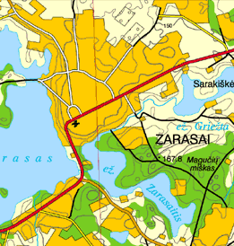
Geographic map of Lithuania National land survey of Lithuania, 2001 |
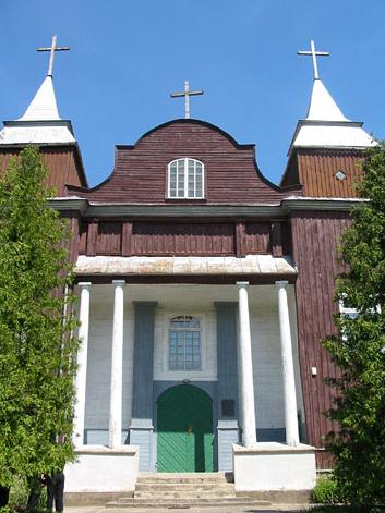
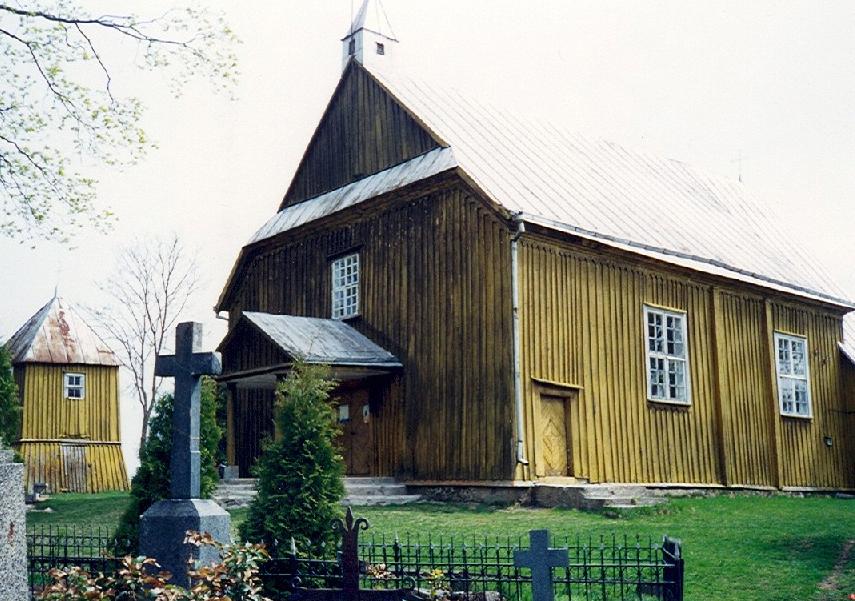
The church Švč. Mergelė Ėmimo į dangų was built in 1878 |
Novoaleksandrovsk, 1898 Topographic map of Russia 1:42000. 1898 |
Jonas Deksnys. THE CHANGES OF PLACE NAMES FROM 13 TO 20 CENTURY
Unpublished manuscript was made 1930-1985.
|
PLACE NAME |
YEAR |
REFERENCE |
|---|---|---|
|
|
1522 |
(10) Aleksandrowicz St. Geneza i rozwoj sieci miasteczek Bialorusi i Litwy do pol. 17 w. "Acta Baltico-slavica VII, 1970. |
|
IEZIORASA |
1613ž |
(1) The Grand Duchy of Lithuania 1:300000. Drawn by T. Makovski. Carved by G.Hesel. Printed by V. Jansson, Amsterdam, 1613. This is the first original map of the Grand Duchy of Lithuania |
|
JEZIOROSCE |
1772ž |
(2) Carte de la Pologne. Rizzi-Zanoni atlase 1:673000. Paris 1772. |
|
JEZIOROSY |
1819 |
(Te) The list of trianguliatio |
|
NOVO-ALEKSANDROVSK
|
1836 |
(RA) Official place names of the administration of Empire of Russia. 1995-1914. Topographic map of Russia 1:42000. 1898 |
|
EŽERĖNAI (Novoaleksandrovsk) |
1900ž |
(5) Map of the Latvian lands in Lithuanien. 1:840000. Made by A.Macijauskas. Saint Petersburg, A. Ilyin's cartography company, 1900. |
|
EŽERIŪNAI |
1902 |
K.Jaunius |
|
ZARASAI |
1911ž |
(6) Map of Lithuania with an ethnographic border. 1:1000000. Made by V.Verbickas. Published by "Lietuvos ūkininko" company. Saint Petersburg, Ilyin's cartography company, 1911 |
|
ZARASAI |
1917ž |
(7) Carte de la Lithuanie 1:500000 Bureau d'Iinformation Lithuaniene Lausanne. Berne. 1917. |
|
ZARASAI |
1920ž |
(8) Map of Lithuania hills and rivers and borders 1:630000. Made by P. Matulionis. Publiched by S.Schropp house, Berlin, 1920. |
|
ZARASAI(Ežerėnai Novoalesandrovsk) |
1923 |
(26) Place names of Lithuania. The data of first general census of the population in 1923. Kaunas, 1925 |
|
OSERSEE |
1941ž |
(VO) Official place names of Lithuania during the occupation of Germany in I and II World War. E.Horn, Verwaltkrt v. Litauen.1941. |
|
ZARASAI
In 1596 Zarasai was mentioned among other settlements of Vilnius Diocese, and two years later it was named a rural district. In 1610 Grand Duke of Poland and Lithuania Zigmantas Vaza built a new church in Zarasai, and in 1613 the township was already marked on the map of the Lithuanian Duchy. However, further development and growth was a long process. An important event in Zarasai history was the construction of Kaunas-Daugpilis road in 1830-1836. Its completion led to livelier goods transportation and post-coach traffic, thus enhancing the role of Zarasai in communication and improving conditions for its development. In 1836, by the order of Czar Nicolai I, the district administration was moved from Vydžiai to Zarasai, the town was renamed Novoalesandrovsk and received its coat-of-arms. The next year the construction plan of Zarasai was approved. During the Independence years Zarasai district was four times smaller than during the czarist occupation. The
district was remote from bigger cities, without railway, industry had
no prerequisites for development. Only small enterprises, mainly for
satisfying the local needs, were being set up in the district :
private water mills, dairies sawmills, etc. Two years later another municipality guest house, officially called a winter sports station, was finished. A new trade hall was constructed, a hospital was opened, new parks and pine woods were planted, a springboard was installed, together with a panoramic view, etc. The citizens could purchase summer cottage plots on special terms. The
region boasts of rich cultural heritage. At present one can find 30
historical monuments in the district: birthplaces or graves of famous
people and monuments to them. The region territory contains 69
archaeological monuments: 29 mounds, 24 barrows, 10 ancient burial
places, 6 archaeological
stones. There are 14 architectural monuments and 71 valuable art
works, most of them in churches. 3 state-owned, 5 public or private
museums and an art gallery are open to visitors. |
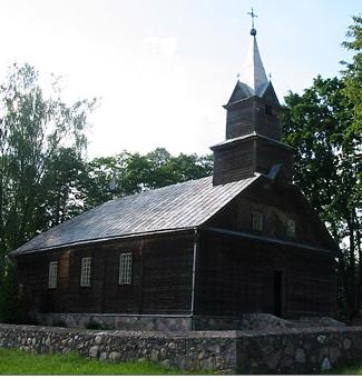
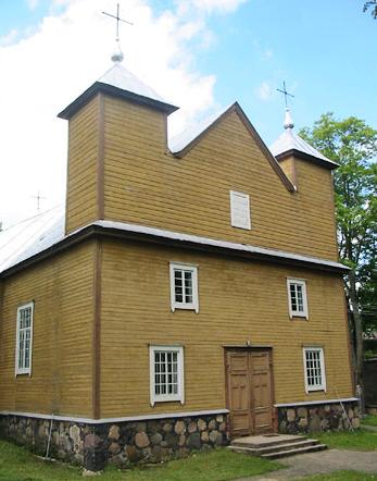
 Village Aviliai district Zarasai The wooden church Šv. Kryžiaus Išaukštinimo was built in 1875. |
 Village Antazavė district Zarasai The wooden church Dievo Apvaizdos was built |
 Village Baltriškės district Zarasai The wooden church Šv. Kazimiero was built in 1920. |
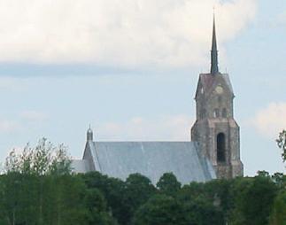 The church Salakas district Zarasai was built in 1911. |
 Village Švedriškės district Zarasai The wooden church Šv. Jono Krikštytojo was built in 1934 |
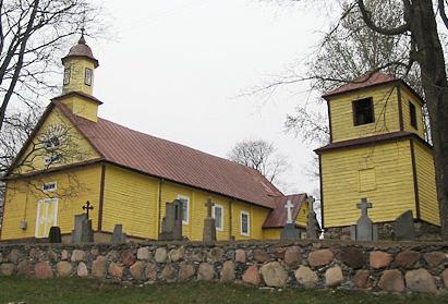
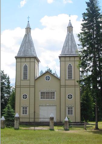
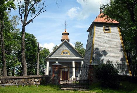
 Small town Dusetos district Zarasai The church Švč. Trejybės was built in 1888 |
 Village Vajasiškis district Zarasai The wooden church Šv. Jono Krikštytojo was built in 1863. |
 Village Imbradas district Zarasai |
 District Zarasai Vector data base LTDBK50000-V, Sheet Zarasai, roads, forests, lakes and other land use borders. National land survey of Lithuania, 1998 |
 District Zarasai Vector data base LTDBK50000-V, Sheet Zarasai, contour lines and rivers. National land survey of Lithuania, 1998 |
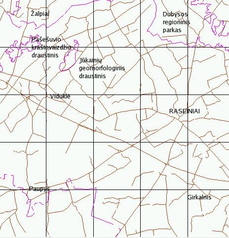
RASEINIAI
town
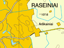 Geographic map of Lithuania National land survey of Lithuania, 2001 |
 Topographic map of Russia 1:42000. 1898 |
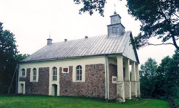
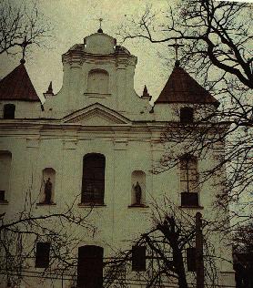 Raseiniai The church Švč. Mergelės Marijos Ėmimo į dangų was built in 1729 |
Jonas Deksnys. THE CHANGES OF PLACE NAMES FROM 13 to 20 CENTURY
The unpublished manuscript was made 1930-1985.
RASEINIAI
|
Place name |
Year |
Reference |
|---|---|---|
|
|
1253 |
Encyclopedia of Lithuania. Kaunas. 1933-41. |
|
RUSSIGENA |
1322 |
(SRP I II) Hirch-Toeppen-Strelke “Scriptores rerum Prussiearum” |
|
|
|
Codex diplomaticus ecclesiae cathedralis necnon dioeceseos Vilnensis/ Kodeks dyplomatyczny katedry i diecezji Wilenskiej. 1387-1468. Krakow, 1932 |
|
RUSSENIA,
ROSSIGEN, RUSHIGEN |
1377 |
(SRP II) Hirch-Toeppen-Strelke “Scriptores rerum Prussiearum” |
|
ROSSYEYN |
1385 |
(SRP w25)Hirch-Toeppen-Strelke “Scriptores rerum Prussiearum” |
|
ROSEJNI, ROSSIJENY |
1575 |
(RŽK) Sprogis J. Geografičeskij slovar drevnej Žomoitskoj zemli 16 century. Vilna. 1888 |
|
ROSEIN |
1595ž |
Lithuania 1:30000. Made by G.Merkator. "Atlas sive cosmographical meditations". Duisburg, 1595 |
|
ROSEINI - SAMOGITIE METROPOLIS |
1613ž |
(1) The Grand Duchy of Lihuania 1:300000. Drawn by T. Makovski. Carved by G.Hesel. Printed by V. Jansson, Amsterdam, 1613 |
|
ROS |
1655ž |
Atlas of V. Jansson. |
|
ROSIENNE |
1716ž |
Poland and Lithuania. From J.B. Homann's "Atlas Novus", 1716. Published by the Lithuanian Information bureau in Lausanne. |
|
ROSIENE |
1772ž |
(2) Carte de la Pologne. Rizzi-Zanoni atlase 1:673000. Paris 1772. (2) |
|
ROSSIENIE |
1806ž |
(R)Topogr. Special-Karte v. Mittel-Europa 1:200000 „Reymanno prad. 1806) |
|
ROSSIENY
|
|
(4) Trechverstnaja topogr. karta Jevropejskoj Rossiji 1:126000.Berlin 1843 |
|
ROSSIENY |
|
Topographic map of Russia 1:42000. 1898 |
|
RASEINIAI |
1900ž |
(5) Map of the Latvian lands in Lithuanien. 1:840000. Made by A.Macijauskas. Saint Petersburg, A. Ilyin's cartography company, 1900 |
|
RASEINIAI |
1911ž |
(6) Map of Lithuania with an ethnographic border. 1:1000000. Made by V.Verbickas. Published by "Lietuvos ūkininko" company. Saint Petersburg, Ilyin's cartography company, 1911 |
|
RASEINIAI |
1917ž |
(7) Carte
de la Lithuanie 1:500000 Bureau d'Ie information Lithuaniene Lausanne.
Berne. 1917 |
|
RASEINIAI |
1920ž |
Map of hills, inclination and borders of Lithuania. 1:630000. Made by P. Matulionis. Published by S.Schropp, Berlin., 1920. (8). |
|
RASEINEN |
1941ž |
(VO) Place names from maps made by German administration during the German occupation in First and Second World War. E.Horn, Verwaltkrt v. Litauen.1941. |
|
RASEINIAI Raseiniai was
virtually ruined during the Second
World War - approximately 90 percent of the buildings were
destroyed. |
 District Raseiniai |
 |
 |
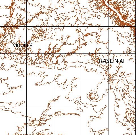
 Vector data base LTDBK50000-V, sheets -Gelgaudiškis, Raseiniai - contour lines . National land survey of Lithuania, 1998 |
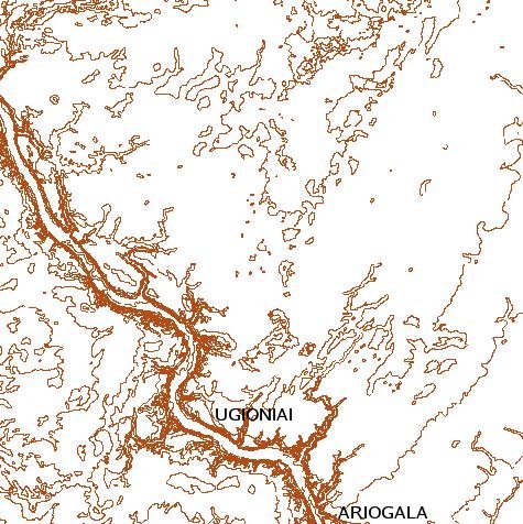
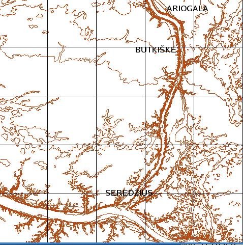 Vector data base LTDBK50000-V, Sheets - Betygala, Ariogal -, contour lines. National land survey of Lithuania, 1998 |
 |
|
| Village Butkiškė
district Raseiniai Thewooden church Šv. Jono Krikštytojo was built in 1939 |
 Village Ugioniai district Raseiniai The church Švč. Mergelės Marijos Ėmimo į dangų was built in 1836 |
 Small town Vidukle district Raseiniai The wooden church Š. Kryžiaus was built in 1806 |